Changes
in Latitude, Changes in Attitude
Greetings
from Santa Cruz, Bolivia!
Well
I made it through the longest country on the planet! Wooo hooo! I didn’t pedal
the entire length of Chile but it feels like it nonetheless so entering Bolivia
was a significant milestone for me.
Chile
gives a new meaning to the word "skinny" with these stats:
Length 2653 miles (4270 km)
Width average 110 miles
(177km)
Widestpoint
221 miles (356 km)
Narrowest
point 40 miles (64 km)
Latitude
range 17° South to 56° South latitude.
At
every passing of a degree in latitude I give a big "Wahoo" out loud.
I
started in Tierra del Fuego at the latitude/longitude of
S
54° 50’ 36”, W 068° 34’ 41” and (someday) will reach Deadhorse,
Alaska at N 70° 11’
30”, W
148° 28’ 38”
I
am currently at N 17° 46’
57.1”, W
063° 11’09.1” which means I have a long way to go!! But if you look on a South
America map and find Santa Cruz, Bolivia (near the border of Brazil at the highest end of the orange line) you can
see that I am halfway through South America!!! My relative location in the
Southern Hemisphere matches that of somewhere between the island nations of the
Saint Kitts and Antigua (in the Caribbean) in the Northern Hemisphere. I am as far south from the equator as Saint Kitts and Antigua is north and my location is about as far east as those islands too.
 |
| The orange is where I pedaled and the black is where I had a ride. |
From
what I have read and talked to about with other cyclists who have done the
length of the Pan American highway, I estimate the distance at about 18,000 miles (30,000 km) depending on
detours/route etc. I have been on the road for 8 ½
months and have made it 3640 miles (6066km). This means
I am only about 1/5 of the way through! Across the USA Betty and I rode 4200 miles (7000 kms) in 3 months! This trip is very different!
My
time off of Tankita is exactly equal to my time riding. I really have enjoyed my
stops to do other things and meet other people and a fair amount of my “down
time” is spent taking care of business/repairs etc on my bike and some business
back home. I am moving slowly but wouldn’t have it any other way.
I
just had 31/2 weeks off of my bike, partly because I was visiting with a friend
who flew here to meet me and visit for two weeks and also because Tankita was getting a bunch of new
parts in preparation for the rest of our journey. She had a major overhaul which
I will explain later. But now after 3 1/2 weeks I’m ready to get rolling again!
My
progress on the bike prior to this last stop has been at a faster pace than
previous progress for sure! There is a noticeable difference in the strength of
my legs and arms. Tankita doesn't feel as heavy as she used to feel and I am
climbing hills at a more steady pace and with greater ease. I anticipate my pace to speed up but who
knows. I am definitely able to pedal more hours per day than before and it
seems my limiting factors now only seem to be the amount of daylight hours that
I have to spend on the road after sleeping in (of course).
As
I venture further north some significant changes have and will take place. For
one, the weather is now a lot warmer (yippee) and I may have to start my days
earlier (yuk), the bugs have become more plentiful, I may encounter creepy
crawlies more (saw a tarantula carcass just recently), and there are more or
less twelve hours steady of daylight hours. The northern countries of South
America and those in Central America and Mexico are significantly cheaper than
Chile or Argentina so I am excited that my money is going further. I will start
to see some darker complexions and more culture and I am excited about that
because I miss diversity. The only diversity that exists around me now is that
inside my iPod (as my music is quite diverse with artists from all over the
globe).
Before
I crossed into Bolivia I had been traveling within the same few degrees of
longitude (West 70°-73°) for most of the trip and I was sticking to the west
side of the continent. Going through Bolivia is a big detour from the
northwesterly direction I should travel to go from Argentina to Alaska.
I
detoured east into Bolivia because:
*I
wanted to cross the Salar de Uyuni, the largest salt flat on earth.
*I
wanted a good warm place to meet that friend of mine who was coming to visit me
while on my trip and Santa Cruz was the best choice in Bolivia.
*I
wanted to return to the area around Santa Cruz, Bolivia, the place where I had
surgery on my leg two years ago for an infected ocelot bite. The bite was
courtesy of Tigre, that beautiful but ornery ocelot with whom I was being
trained to take care of at the time. While I was recovering from the surgery I
had to stay in the Santa Cruz area to visit the surgeon every few days to check
on the wound so I got to know the city and an organic farm to the south called
“Ginger’s Paradise” which I revisited also.
*I
want to visit Noel Kempff National Park a world heritage site for its
biodiversity. When I was in the hospital in Santa Cruz, mounted on the wall in
my room was a beautiful photo of somewhere in that park. Since I saw that photo
I have wanted to go to that park and now with my Eastern detour towards Brazil
I will finally make it there. I’m heading that direction when I leave Santa
Cruz.
 |
| Photo in my hospital room of Noel Kempff Mercado National Park |
I
was asked by a friend if I can ¨indulge
in an extra day or two in a place that interests¨ me and the
answer to that is “most definitely!” I learned a phrase in Spanish awhile ago
and it sums it up nicely “Yo no tengo prisa” or “I am not in a hurry.”
Below are photos starting where I left off in my posting of ¨I Cry for You Argentina.¨ That was the last posting with representative photos of my travels. Wow, that was in June am I ever behind!!
 |
| It seemed like I was just keeping ahead of winter as it was just turning fall everywhere I went for awhile. I never really hit unbearable winter temps but only super low temps because of altitude. |
 |
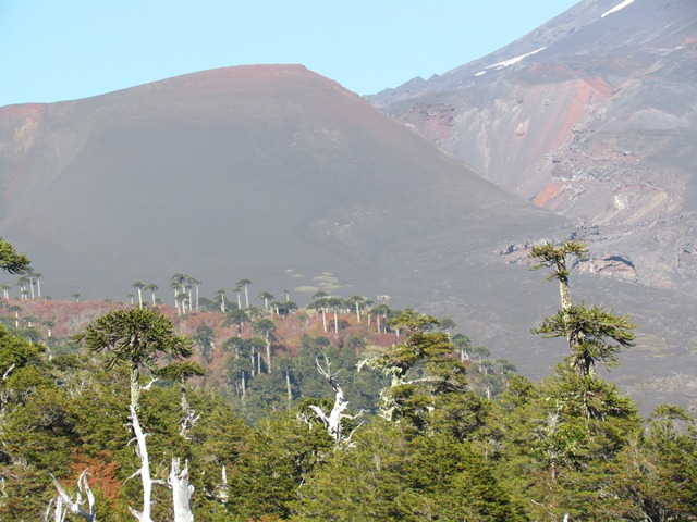
| Conguillo National Park-a girl I met in Futaleufu told me of this park and the special Araucaria trees there. The following -- photos are of this park. |
 |
| I wasn´t lucky enough to see any volcanic activity! |
 |
| The roads through the park were less than desirable at times. |
 |
| The mother Araucaria, she was a big one at 1800 years old, 165 feet (50 meters) high and about 7 feet (2.1meters) in diameter! |
|
|
|
 |
| View up from my tent. I wasn´t supposed to camp here but that is the beauty of being stealth with a bike. |
 |
| More Araucaria trees. They filmed some of ¨Walking with Dinosaurs¨ here. |
 |
| My friend Susan (photos were posted with her and I hiking together in Torres del Paine blog) showed me a pose that is a joke between her and her Dad-this is me imitating that; the fingers make W´s and the mouth makes an O forming the word ¨Wow.¨ This pose is only for deserving ¨Wow¨ places. |
 |
A friend to lean on sleep on. |
 |
| I got nailed by bugs one night inside a guest house. My face was the only part out of my sleeping bag. |
|
|
|
|
|
|
| | | | |
|
|
 |
| As I started getting more north I had to stay in guest houses more often because of the concentration of towns and people. At least a nice place like this only costs about $16/day, more than my budget but cheap by most people´s standards. |
 |
| Creative |
 |
| Yeah, the coast!! |
 |
| Visiting friend in my bathroom |
 |
| The name of this place is San Francisco, go figure! |
 |
| Rules, rules, rules! I won´t tell you the way I went here. |
 |
| Pool on the rooftop of Stuart´s apartment building in Santiago. Too bad about all the smog. |
 |
| Santiago |
 |
| Valparaiso |
 |
| Ascensor/Elevator going from one part of Valparaiso (Valpo for short) to another. There are lots of these in Valpo so that the inhabitants don´t have to walk all of the hills here. |
 |
| View from above the ascensor/elevator. |
 |
| Valpo is full of colorful houses and graffiti murals and is a World Heritage Site. |
 |
| Cops have to ride motorcycles here to be able to maneuver through the stairways and hills. I wish I had a better photo of this but the cop went down all of the stairs. |
 |
| Interesting stuff to have on a house. |
 |
| North of Valpo in the rich area of the country. |
 |
| Looks like Florida |
 |
| Reminds me of the California coast. |
 |
| Sea lions just like on the California coast too! |
 |
| This looks like Malibu, California, now this is getting weird with all of the similarities. |
 |
| Complete with a fancy pool |
 |
| The dirt road to Lorraine´s house, what a beautiful neighborhood |
 |
| Back on the freeway, you would think it was a bad road to ride on but it had a beautiful shoulder and the road was well maintained. |
 |
| Another tube bites the dust |
 |
| It was starting to look pretty arid here close to the coast north of Valparaiso |
 |
| And the Copec sign glowed like the moon shining down as I camped behind the gas station |
 |
| I love pelicans! |
So as not to overload you with too many photos in one blog and so that I don´t take any longer posting this new blog I am posting this one up to this point just before La Serena, Chile which is still behind but I´m getting there!
Stay tuned for the Atacama Desert and Salar de Uyuni crossings!